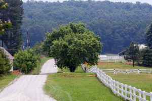
The business card and other communication vehicles that promote the Leeds Scenic Byway feature this photo of a winding road leading to a mountain. Leeds’ byway, an Alabama State Byway on Alabama State Hwy 119, has been traveled by horses, wagons, and early automobiles. It meanders for eight miles through a rural vista and small town where more than 33 homes, businesses, museums, and cemeteries display county, state or national historic markers. Six interpretative exhibits tell the stories of a pioneer culture that continues to produce war heroes, scholars, athletes, entertainers and builders. Ultimately, Leeds is “Central Park‚Äù to the largely urban Jefferson County, Alabama. It is a getaway for those who love nature and a small-town atmosphere. The scenic byway threads itself through the landscape, knitting together an intensive history of citizens with diverse ancestries, stories of heroism, and the area’s natural beauty.
AL State Hwy 119 – U.S. 411 through Leeds, AL from Grants Mill Road to I-20
GPS Coordinates for geocaching the byway follow:
Find photographic opportunities while you explore by geocaching the byway with the following coordinates:
Find picnic food N33 33 42.729 W86 31 20.662; N33 33 39.1014 W86 31 15.32856
Find the monkey’s information N33 32 38.72 W86 32 32.23
Find the genealogist’s treasures N33 32 36.75 W86 32 30.85;
N 33 32 59.4636 W 86 32 28.89384
Find the patriot’s amazement N 33 32 22.95384 W 86 33 43.51104
Find relaxation and playgrounds by a stream N33 32 24.81 W86 33 28.54
Follow leafing N 33 31 28.7274 W 86 34 40.4232 take next right onto Elliott LN; N 33 28 31.54152 W 86 37 35.17104 take next right onto Grants Mill Road; find Rex Lake Road and this intersection N33 32 32.95 W86 35 30.28.
Keep going: N 33 31 28.92 W 86 34 42.68; N 33 32 34.43 W 86 32 25.71; N 33 32 40.01 W 86 32 40; N 33 32 32.44 W86 32 40.0; N 33 33 25.5996 W 86 31 34.32108.
http://www.leedsscenicbyway.org/ | , Leeds, ALphall@windstream.net, 205-699-3760
AL